
Marco Almeida
Art Director at Craytive Technologies
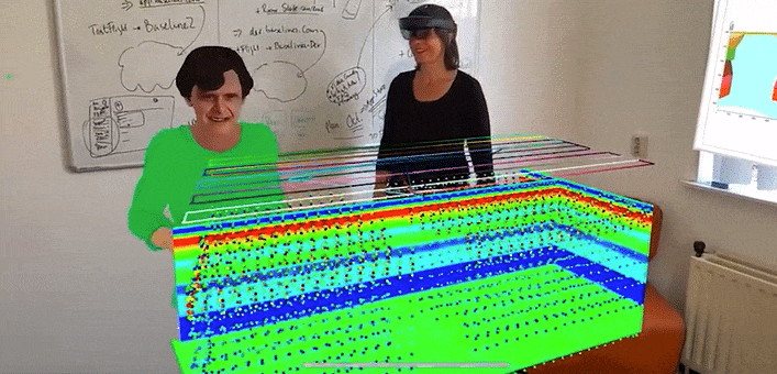
Mobile Geophysical Technologies (MGT) and Craytive Technologies used BaselineZ to visualize and collaborate on the 3D resistivity model obtained from a semi airborne electromagnetics survey (2020) in Northern Germany.
When discussing the first time with Johannes the possibility of visualizing drone borne geophysics data in BaselineZ, both of us got excited. So, I couldn’t wait to get an example data set to load in BaselineZ. Now it is amazing to see the 3D resistivity model together with the flight routes on top in true 3D just out in the field. And looking ahead, what a chance to demonstrate the results of geophysics surveys to stakeholders in true 3D.
SME Geoscience, Katja Schulze
The Semi-Airborne EM method applied in this study uses a horizontal electric dipole on the ground to generate electromagnetic signals in the range between 10Hz to some 10s of kHz. The receiver is mounted to the drone and measures the resulting electromagnetic field along the flight profiles. This novel geophysical method makes use of numerous frequencies which allow for modeling the resistivities over a large depth range with unprecedented high resolution – and thus for creating a detailed 3D resistivity model of the subsurface.
In the below video you can see us inspecting the resistivity model at a local park, using BaselineZ. We entered a real-time collaboration session from the Netherlands and remotely from Germany, with our MGT colleague showing as a 3D Avatar.
The 3D resistivity model extends 1000m x 500m x 300m with bluish colors indicating low resistivity and reddish colors high resistivity. The model indicates a layered subsurface with a low resistivity zone in roughly 200m. The low resistivity is likely caused by salt from a nearby Permian salt diapir dissolved in a deep aquifer.
The real-time 3D Visualization and Collaboration capability of BaselineZ, allows us to interactively participate in the discussions and get a better understanding of geological features from different perspectives. All participants can simultaneously interact with the 3D mode
Drone borne geophysics facilitates obtaining extensive survey data and building 3D subsurface models – and thus calls for state of the art immersive 3D visualization and collaboration.
Drones
With BaselineZ we were able to bring the reservoir model to the outcrop. This was a truly fantastic experience to visualize the reservoir model in real 3D in front of you, while investigating potential reservoir facies in the field. We were able to discuss the different reservoir scales, hierarchies and structural complexities on the ground, bridging the gap between the model domain and field observations.
Research Associate, Gerd Winterleitner
Engaging with policy-makers and politicians is a vital step in geothermal project development and we decided to use BaselineZ as the main communication platform. Leveraging on the BaselineZ presentation mode and capabilities to showcase additional cultural data (Pdfs, Images etc.). The data room visualization was enormously helpful to present and discuss the project and get key messages across to a non-geoscience audience. The immersive visualisation creates an intuitive understanding of the 3D nature and scale of the project and facilitated the decision-making process.
BaselineZ proved to be an excellent platform throughout the entire workflow for our geothermal reservoir project. Geoscience meets the metaverse and this will be a vital contribution to the success of the energy transition.
CEO MGT, Johannes Stoll